This weekend we made a trip up north which included a stop at the Bellingham Railway Museum. It's not a very big museum—it occupies a storefront downtown—but it does a good job of illustrating the importance of railroads to the history of Bellingham and Whatcom County through plenty of photos and maps. And, of likely greater interest to readers of this blog, there's a G-scale railroad right in the middle of it!
The railroad models some of the industries that were important to the establishment and growth of Bellingham, specifically logging, lumber mills and coal mining.
 |
| A Bloedel Donovan Lumber Mills 2-6-6-2 heading across the trestle. I think this is a Baldwin Logging Mallet? |
 |
| Logging camp with spar and cables on the left. |
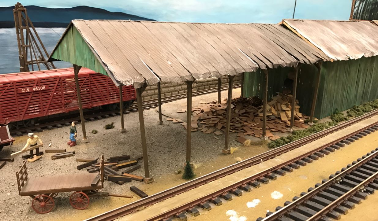
 |
| Close up detail showing the wood-fueled crane for loading logs. In this camp there were both skeleton log cars and trucks without center beams which could be used for logs of varying lengths. |
 |
| Log dump and pond next to the lumber mill. |
 |
| A growing pile of cedar shakes outside the shake mill. |
 |
| Close up of a skeleton log car. |
 |
| A coal tipple and a couple of hoppers waiting to be loaded. |
In addition to a rail lines, Bellingham had a number of electric trolley lines that linked neighborhoods. This map shows the full extent of the trolley system and its growth over time, and also shows the electric interurban line (#10) heading south out of town. Originally the Bellingham & Skagit Interburan Railway, it was known as the Pacific Northwest Traction Company at the point in time this map represents. Starting in 1912 it was possible to travel by interurban from Bellingham to Mount Vernon in a little over an hour, with a car leaving each end point every 90 minutes.
 |
| Historic trolley and interurban routes overlaid on a contemporary map of Bellingham. |
The Bellingham Railway Museum also had a beautiful railroad map of Washington from the late 1920's. I've seen this map before but not as well preserved as this one -- the colored lines are all bright and vibrant. The purpose of displaying this map was of course to show Bellingham railroads in context of the whole state, but I was immediately draw to my favorite part. The detail below is a closeup of Whitman County and I've highlighted the towns of Palouse and Elberton. This map shows the maximum extent of track building on the Palouse and shows all six railroads that served the area:
- Oregon Railway & Navigation (dark brown)
- Northern Pacific (red)
- Spokane, Portland & Seattle (purplish-gray)
- Washington, Idaho & Montana (not in color on the map, just a hashed line headed east from Palouse)
- Milwaukee, St. Paul & Pacific (orange)
- Spokane Coeur d'Alene & Palouse (green, shown on the map as the SC&P, but often referred to by its older name, Spokane & Inland Empire)
 |
| Detail of 1920's map showing full extent of railroad building on the Palouse. |
One additional railroad of note on this map is the Camas Pairie Railroad which you can see at the bottom of the image along the north bank of the Snake River. It did not build tracks up onto the Palouse, but it did still serve local farmers by exporting grain from stations along the river.
Links for more information:


No comments:
Post a Comment